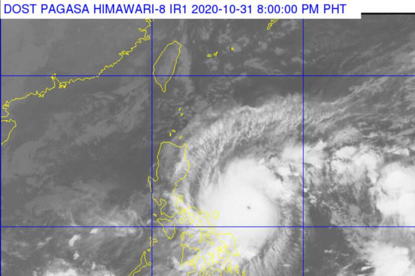
Metro Manila (CNN Philippines, October 31) – State weather bureau PAGASA on Saturday raised Signal No. 3 in Catanduanes, as Typhoon Rolly maintained its strength.
This alert means that disruption of electrical and communication services is expected, as well as damage to trees, crops and infrastructure made of light materials in the next 18 hours.
Meanwhile, more areas were added under Tropical Cyclone Wind Signal No. 2, as the cyclone continues to head to the Bicol region.
The central and southern portions of Quezon including Polillo Islands, Ticao Islands, and Marinduque add to the list which includes Camarines Norte, Camarines Sur, Albay, Sorsogon, Burias Island, and Marinduque, according to the 11 a.m. bulletin.
The lowest storm warning is hoisted in the rest of Masbate, the rest of Quezon, Rizal, Laguna, Cavite, Batangas, Romblon, Occidental Mindoro including Lubang Island, Oriental Mindoro, Metro Manila, Bulacan, Pampanga, Bataan, Zambales, Tarlac, Nueva Ecija, Aurora, Pangasinan, La Union, Benguet, Ifugao, Nueva Vizcaya, Quirino, and the southern portion of Isabela.
Some areas in the Visayas are also under Signal No. 1 such as the northern portion of Samar, the northern portion of Eastern Samar, and Biliran.
PAGASA weather specialist Benison Estareja said in a briefing that Signals 3 and 4 may be raised in parts of Quezon province and Bicol within 24 hours.
Estareja said the second to the highest storm alert may be raised in Metro Manila if Rolly maintains its strength after its forecast landfall in Quezon.
“Over Metro Manila, ang forecast natin for now is up to Signal No. 3 pero hindi natin niru-rule out ang (but we are not ruling out) Signal No. 4,” he said.
Forecasters said Rolly will reach super typhoon category in the next 12 hours as it tracks the Bicol region on Sunday. A super typhoon packs winds of more than 220 kph.
“It is as fast as a bullet train and double the speed of a vehicle traversing an expressway,” said Estareja in describing a super typhoon.
Smaller than ‘Yolanda’
Rolly is deemed strong but its diameter is smaller than Typhoon Yolanda, which killed over 6,000 people when it battered several parts of the country in 2013.
This means Rolly will affect fewer areas than Yolanda, with its heavy rains and strong gusts to be mostly felt on areas along its path such as Bicol, Calabarzon, Bicol, Metro Manila, and Central Luzon.
“Ito po ang mga rehiyon kung saan kritikal ang paghahanda dahil dito mararanasan ang mga mapaminsalang hangin,” PAGASA weather specialist Ariel Rojas told CNN Philippines’ Newsroom Weekend.
[Translation: These are the regions where preparation is critical because of the expected destructive winds.]
Landfall
The typhoon is seen to pass close to the Calaguas Islands this morning and hit Polillo Island and mainland Quezon in the afternoon or evening, PAGASA said.
Rojas said the forecast track may change depending on the strength of a weather system.
“Kapag lumakas ang high-pressure area ay posible na itong maglandfall sa Catanduanes. Kapag ito humina ay posibleng dumaplis ang eyewall sa may northern part ng Bicol region,” Rojas told CNN Philippines’ Newsroom Weekend.
[Translation: If the high-pressure area gains strength, it is possible for Rolly to make landfall in Catanduanes. If it weakens, its eyewall may hit land in the northern part of the Bicol region.]
Nonetheless, PAGASA warned of violent winds and intense rainfall in Catanduanes, Camarines Norte, and the northern portion of Camarines Sur and Quezon, and the southern portion of Aurora on Sunday.
As of 10 a.m., the eye of Typhoon Rolly, last seen east of Virac, Catanduanes, still had maximum winds of 215 kph and gusts of up to 265 kph.
In 48 hours, Rolly will exit the Philippine Area of Responsibility as a severe tropical storm, PAGASA said.
Meanwhile, PAGASA is also monitoring Tropical Depression Atsani, last spotted 1,605 km east of Visayas outside the monitoring area.
Atsani is expected to enter the Philippine Area of Responsibility by Sunday afternoon or evening, and will be named Siony. It may make landfall in northern or Central Luzon.
Red Cross alert
The Philippine Red Cross (PRC) has alerted staff and rescue and emergency units (PAGASA) warned that “Rolly” could become a super typhoon in the next 12 hours.
PRC Chairman Richard Gordon said the agency is on full guard as typhoon Rolly (international name: ‘Goni’) is forecast to hit the country with heavy rains and strong winds up to 215 kph today.
Red Cross is beefing up its disaster management services, through its local chapters, with all rescue vehicles, logistics hubs, and emergency response units are ready for the typhoon.
PRC has also alerted all its 104 chapters to regularly report the situation in their areas to be able to deliver immediate response and forecast-based action once “Rolly” hits the communities.
The PRC Operation Center hotline 143 will be active 24/7 to answer calls.
“Everyone is encouraged to be equipped with kits and food relief, and be vigilant through their communication line to keep track of the typhoon’s run,” Gordon said as he reminded the public the need to PREDICT, PLAN, PREPARE, and PRACTICE for a disaster.
“Predict, Plan, Prepare, and Practice,” Gordon emphasized “We will be responsive to these back to back catastrophes. PRC readie
The Red Cross has deployed teams in response to these weather disturbances by providing assistance during pre-emptive evacuations, giving out hot meals to stranded individuals and helping local government units in the clearing operations.
“Preparation is the best defense as our country has long been an inevitable arena of typhoons and other natural disasters. The Philippine Red Cross has always been first, always ready, and always here,” Chairman Gordon assured. By CNN Philippines Staff

